
TSPS Category 6 – Registered Professional Land Surveyor
Topographic Survey & Elevation Mapping
A detailed elevation and contour map of your land’s surface — serving North & East Texas.
Licensed in Texas · Same-week Field Visits · GPS + Total Station
What is a Topographic Survey?
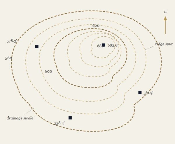
A topographic survey — often called a topo or contour survey — is a detailed, on-the-ground map of your land’s surface, showing elevation changes along with the natural and man-made features that sit on it.
A surveyor walks the site taking measurements at set intervals, using GPS and total station equipment, and records elevation and location data across the property.
The result is a series of contour lines showing the height, depth, and location of every manmade or natural feature on the parcel — from slopes and drainage paths to trees, structures, and utilities.
Rather than only showing where property lines fall, a topographic survey reveals how the land actually behaves — where it rises, where it drains, and where it’s stable enough to build.
The surveyor then compiles this data into a certified, sealed topographic map or plat — a detailed drawing showing contour lines, elevations, and existing site features, ready for use by architects, engineers, and developers in project design.
What’s Included?
Field Elevation Data
Spot shots and break lines collected across the site with GPS + total station.
Contour Mapping
Contour lines showing slopes, drainage paths, and elevation changes.
Site Features & Utilities
Manmade and natural features — structures, utilities, and improvements — located on the parcel.
Signed & Sealed Topo Map
A recordable drawing and digital file, stamped by an RPLS for engineer/architect use.
Why You Need a Topographic Survey
A topographic survey shows you what your land really looks like. It maps the slopes, low spots, and existing features on your property before you build anything. This matters because surprises are expensive. Soft soil or a hidden dip in the land can cause big problems mid-project. It’s much cheaper to find these things on paper than to find them during construction.
A topo survey also helps engineers plan the dirt work. They can figure out how much soil to move, and where, before work starts. This keeps your budget on track. Many cities also require this data before they approve a building permit. They want to see how your project will handle rain and runoff. A topo survey gives them that proof.
In short, this survey turns guesswork into a real plan.
How Much Does a Topographic Survey Cost?
Prices vary based on your lot size, the land itself, and how much detail you need. For a typical home lot in Texas, expect to pay somewhere around $750 to $2,500.
Furthermore, larger lots cost more. So do lots with thick trees or steep slopes, since crews need more time to collect accurate data. Big or heavily wooded properties can run $3,000 to $6,500 or more.
A few things raise the price:
- Lot size — bigger lots cost more overall, but often less per acre
- Land type — trees and slopes take more time to survey than flat, open ground
- Detail level — a tighter contour interval means more data points
- What you need in the end — a simple map costs less than a full survey with elevation points and a digital model for engineers
When Do You Need a Topographic Survey?
You need a topographic survey any time the shape of your land matters to your plans. Here are the most common cases:
- Before you build — architects need slope and drainage data to design a foundation that holds up over time
- Before grading or clearing land — a topo survey gives engineers a starting point to plan how much dirt to move
- If you have drainage problems — mapping how water flows across your land is the first step to fixing it
- When you apply for permits — many cities want proof that your project handles rain and runoff the right way
- When land changes use — turning a rural lot into a subdivision or commercial site usually calls for a fresh survey
- Even for smaller home projects — pools, additions, or landscaping on a sloped lot benefit from this data too
If your lot has any slope or planned changes, it’s worth asking for a topo survey before you start designing.
Ready to Find Your Property Line?
DMC Henry Surveying provides accurate, court-recognized boundary surveys throughout DFW, North Texas, and East Texas. Whether you’re buying a home, building a fence, or settling a dispute with a neighbor, our licensed surveyors give you the clear answer you need.
Areas We Serve
From Sulphur Springs to Dallas-Fort Worth, we handle topographic surveys across North and East Texas — including Greenville, Farmersville, Midlothian, Weatherford, and dozens of communities in between. Don’t see your city listed? Give us a call — there’s a good chance we already work in your area.
- Sulphur Springs, TX
- Mt. Pleasant, TX
- Hagansport, TX
- Greenville, TX
- Caddo Mills, TX
- Farmersville, TX
- Princeton, TX
- Royse City, TX
- Melissa, TX
- Anna, TX
- Van Alstyne, TX
- Dallas-Fort Worth, TX
- Midlothian, TX
- Ennis, TX
- Weatherford, TX
- Cleburne, TX
- Waxahachie, TX
- Terrell, TX
- Forney, TX
- Kaufman, TX
- Rockwall, TX
- Denton, TX